We've launched the new forums! Read more here
Navigation
Install the app
How to install the app on iOS
Follow along with the video below to see how to install our site as a web app on your home screen.

Note: This feature currently requires accessing the site using the built-in Safari browser.
More options
You are using an out of date browser. It may not display this or other websites correctly.
You should upgrade or use an alternative browser.
You should upgrade or use an alternative browser.
Evacuated!!
You are using an out of date browser. It may not display this or other websites correctly.
You should upgrade or use an alternative browser.
You should upgrade or use an alternative browser.
- Joined
- Sep 11, 2013
- Messages
- 74,780
- Reaction score
- 88,333
- Location
- Ponte Vedra, Florida
- Handicap
- 11.9
That is scary crazy man! Glad you and your family are safe.
- Joined
- Jul 2, 2018
- Messages
- 8,720
- Reaction score
- 10,455
- Location
- Sierra Foothills, CA
- Handicap
- --17--
- Thread starter
- #53
Yes, actually the fire is in the mountains just east of Placerville, and south of the highway to Lake Tahoe.Hope all is well. Prayers etc are with you.
Nearly thirty years ago, I drove from San Francisco to Lake Tahoe , taking my parents on their only ever road trip in USA. We went through a small town called Placerville, where we picked up some peaches from a road side stall. They were the best peaches we have ever tasted and the place is locked in my mind. Is that near you?
The smoke is really bad this morning, pretty much no wind last night is helping slow things down a bit, and the calmer air is letting the smoke settle in everywhere. The latest update has the fire at a bit over 62,000 acres, and still 0% containment. It looks like the greatest fire fighting efforts are along the western and northern edges. Even though the fire has consistently moved to the north-northeast, the efforts along the west side are to protect the greater population areas in case of a drastic shift in the winds. The focus along the northern edge of the fire is trying to keep it from jumping Hwy 50.
- Joined
- Jun 4, 2010
- Messages
- 11,500
- Reaction score
- 19,180
- Handicap
- PBR
So crazy. Glad to hear you're safe.
- Moderator
- #55
Wow.
MrBlast
Well-known member
Wow. Is that near Auburn? I used to live out in Sac and spent many weekends on the American River near Auburn. Hope everyone stays safe out there.I would guess many across the country might have seen news of the "Caldor Fire" that went crazy last night and today in the Sierras east of Sacramento California. Well the fire started Saturday, and through Monday afternoon it was relatively small, for a wild fire out here, around 700 acres or so, in an area I know really well, and quite a ways from our home. This morning we woke up to find it had gone crazy overnight, had grown to around 6,500 acres, and was a couple of ridges to the east of our house, and moving primarily north and a bit east. I never felt we were in danger, but around 8:00 this morning we were informed we were in a mandatory evacuation area. We got ourselves, our dog, and some stuff we wouldn't want to lose (cars, kayaks, dirt bike, GOLF CLUBS!), out and down the hill a ways, and we are staying with some friends.
The fire really has been completely out of control today, growing to over 30,000 acres, devastating a couple of communities, and threatening others. We are still confident our home is safe, things would have to really go extraordinarily sideways to threaten our little community, and I think we might be some of the first allowed to return home in the next day or two. We have many friends that might not be as lucky as us in that regard, with homes in extreme danger, hopefully all will be safe and will have homes to return to.
We've lived in our house for 31 years, and this is the first time we've had to evacuate, and it is an eye opening experience. I couldn't imagine the stress level of those that are in greater danger of losing everything, because even being pretty sure our home is safe, it has been a very trying day.
I probably won't have many opportunities to be online until we get back home, and I just needed to type this up as a way of venting a bit at the end of a tough day.
- Joined
- Jul 2, 2018
- Messages
- 8,720
- Reaction score
- 10,455
- Location
- Sierra Foothills, CA
- Handicap
- --17--
- Thread starter
- #57
Not Auburn, which is along I-80, and the North and Middle Forks of the American River, it is south of there, near Placerville, which is along Hwy 50 and the South Fork of the American River..Wow. Is that near Auburn? I used to live out in Sac and spent many weekends on the American River near Auburn. Hope everyone stays safe out there.
For anyone interested, here is a link to wildland fire cameras stationed throughout the West Coast. There are some beautiful views of the West Coast, and some horrifying views of the wild fires and smoke.
http://beta.alertwildfire.org/region/tahoe/?camera=Axis-Sierra
http://beta.alertwildfire.org/region/tahoe/?camera=Axis-Sierra
Glad you are ok and hope my daughter does a good job getting resources working in the right area. California is a mess. Fire. No water. Too dry. Beautiful state but too many issues for me. And everything is way more expensive
Sent from my iPhone using Tapatalk
Sent from my iPhone using Tapatalk
- Joined
- Aug 30, 2018
- Messages
- 26,581
- Reaction score
- 22,314
- Location
- Yukon Territory, Canada
- Handicap
- 9.2
That’s incredible.the latest satellite imagery with 2 day growth highlighted
8/17 is left of actual, anything blue is smoke, and as of this image the north end of the fire was a quarter/half mile from US50
View attachment 9023297
MrBlast
Well-known member
Right where the North and Middle forks met is where we used to party. Cliff jump, swim and raft. Every day at around 3pm, the would let water out of a dam, upstream on the Middle fork and the water would suddenly rise about 4'. The water would get rough at that time and the rafting was more fun. We had a lot of fun on that river. Has it really been 30 years? Time flies.Not Auburn, which is along I-80, and the North and Middle Forks of the American River, it is south of there, near Placerville, which is along Hwy 50 and the South Fork of the American River..
- Joined
- Jul 2, 2018
- Messages
- 8,720
- Reaction score
- 10,455
- Location
- Sierra Foothills, CA
- Handicap
- --17--
- Thread starter
- #64
Morning Update:
So the fire has expanded to about 73,500 acres, most of that growth is along the east side, where there were some spot fires that had started a good distance out from the main fire, and they have now burned enough to merge into the main fire. Still reporting 0% containment, which is a bit nerve-wracking. With all the work they've so far successfully put into the western part of the fire, which is where it is closest to populated areas, and the northern part, to keep it from crossing Hwy 50 and the South Fork of the American River, we have been hoping they could actually claim some containment in those areas.
It's still so smokey we can't see anything either, visibility is down to a mile or so, and the closest part of the fire from my house is about five or six miles. Normally we could go up our road a ways where there is a good overlook, and especially at night we would see the glow in the sky from the fire to get an idea of where things are happening in relation to where we are at, but it is so smokey we can see nothing, day or night.
Those of us that have returned to our homes, and those that never left our neighborhood, are still pretty confident the fire won't come this way, but we are all ready to go again if we have to.
TheHeez
Well-known member
Forest Service has closed 9 National Forests in CA to all access, this to try and prevent any additional fire activity. Firefighting resources are stretched and between Dixie, Monument, McFarland and Caldor Fires they don't want anything else to pop off. Looks like they've got a little containment on Caldor (5%), but that happens as the fire burns to containment lines that hold. Hopefully the cooler weather sticks around a little longer and they can fortify the lines. The last few years in CA have been terrible, record setting fires have become an annual event. Sucks.
- Joined
- Jul 2, 2018
- Messages
- 8,720
- Reaction score
- 10,455
- Location
- Sierra Foothills, CA
- Handicap
- --17--
- Thread starter
- #68
Monday Morning Update:
So the Caldor fire has been burning for over a week now, this is the seventh day since it really took off, and it is now over 100,000 acres. We have been pretty lucky with the weather, way cooler than normal for August, humidity is never much around here, but what there is has been better than normal, and winds have been mostly calm the last few days, blowing out of the southwest, which pushes most of the fire away from the more populated areas, but the calm nights are allowing for a down-slope flow overnight and in the mornings which doesn't help with the westward creep @aljaklaw mentioned.
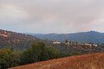
Here is a photo taken from a viewpoint down our road from our house, looking east at the southern end of the fire. The town of Grizzly Flats that was pretty much completely leveled would be close to the middle of the picture, on that furthest ridge line you can just see through the smoke (about 7.5 miles away). A little left of center there is some smoke coming up between the two furthest ridges, just about 5 miles away, and is the closest area burning near us.

- Joined
- Jul 2, 2018
- Messages
- 8,720
- Reaction score
- 10,455
- Location
- Sierra Foothills, CA
- Handicap
- --17--
- Thread starter
- #69
Tuesday Update:
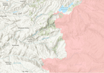
Not too much change around here today, but it is a pretty stressful situation with the fire as close as five miles from the house from a couple of directions. I'm kind of between Pleasant Valley and Somerset on the map below (closer to Pleasant Valley), and although the winds have been primarily out of the southwest, blowing the main fire away from us and towards Lake Tahoe, the western edge of the fire at the bottom of the map below, and the part just below Jenkinson Reservoir, keep inching their way west towards us, and a much more populated area.

Latest update on stats shows over 117,000 acres burned, confirmed 632 structures destroyed and 34 damaged, and 9% containment.
Not too much change around here today, but it is a pretty stressful situation with the fire as close as five miles from the house from a couple of directions. I'm kind of between Pleasant Valley and Somerset on the map below (closer to Pleasant Valley), and although the winds have been primarily out of the southwest, blowing the main fire away from us and towards Lake Tahoe, the western edge of the fire at the bottom of the map below, and the part just below Jenkinson Reservoir, keep inching their way west towards us, and a much more populated area.

Latest update on stats shows over 117,000 acres burned, confirmed 632 structures destroyed and 34 damaged, and 9% containment.
Tuesday Update:
Not too much change around here today, but it is a pretty stressful situation with the fire as close as five miles from the house from a couple of directions. I'm kind of between Pleasant Valley and Somerset on the map below (closer to Pleasant Valley), and although the winds have been primarily out of the southwest, blowing the main fire away from us and towards Lake Tahoe, the western edge of the fire at the bottom of the map below, and the part just below Jenkinson Reservoir, keep inching their way west towards us, and a much more populated area.
View attachment 9023967
Latest update on stats shows over 117,000 acres burned, confirmed 632 structures destroyed and 34 damaged, and 9% containment.
Hoping the best for you. Stay safe!
I'm glad that you and your family have gotten to safety and hope the fire gets under control soon!!
Glad you were able to return home. Hopefully they can get a handle on this soon.
- Joined
- Jul 2, 2018
- Messages
- 8,720
- Reaction score
- 10,455
- Location
- Sierra Foothills, CA
- Handicap
- --17--
- Thread starter
- #75


